What remains of the original Fort McDowell military outpost amounts to little more than a couple of crumbled stone structures located near the current Recreation Center.
During the 10th …
You must be a member to read this story.
Join our family of readers for as little as $5 per month and support local, unbiased journalism.
Current print subscribers can create a free account by clicking here
Otherwise, follow the link below to join.
To Our Valued Readers –
Visitors to our website will be limited to five stories per month unless they opt to subscribe. The five stories do not include our exclusive content written by our journalists.
For $6.99, less than 20 cents a day, digital subscribers will receive unlimited access to YourValley.net, including exclusive content from our newsroom and access to our Daily Independent e-edition.
Our commitment to balanced, fair reporting and local coverage provides insight and perspective not found anywhere else.
Your financial commitment will help to preserve the kind of honest journalism produced by our reporters and editors. We trust you agree that independent journalism is an essential component of our democracy. Please click here to subscribe.
Need to set up your free e-Newspaper all-access account? click here.
Non-subscribers
Click here to see your options for becoming a subscriber.
Register to comment
Click here create a free account for posting comments.
Note that free accounts do not include access to premium content on this site.
I am anchor
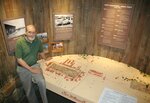
The Fort: Scale model of Fort McDowell at museum
Alan Pape stands alongside his scenic Arizona painting, one of two, along with the model of Fort McDowell, which will become part of his contribution to the River of Time Museum.
Pape shows off the scale model of the original Fort McDowell that he and his crew (Kathy Madden, Deb Cone and Mike and Stephanie McWethy) put together for the River of Time Museum.
Posted
What remains of the original Fort McDowell military outpost amounts to little more than a couple of crumbled stone structures located near the current Recreation Center.
During the 10th anniversary for the L. Alan Cruikshank River of Time Museum held in early March, however, artist-in- residence Alan Pape unveiled his latest project, a scale model of the original Fort McDowell as it stood more than 100 years ago.
Working with helpers Kathy Madden, Deb Cone and Mike and Stephanie McWethy, Pape and his crew decided to tell a unique part of Arizona history by giving museum visitors a look at what the area resembled shortly after the Civil War.
“My first year here I was interested in the reaction of people as they went through the museum,” Pape said.
“I heard a number of people mention Fort McDowell, asking where it was and what it really looked like. So I put in a proposal to create this museum diorama, a scale model of the fort as it looked the last full year it was being used.”
Pape has been working with the River of Time Museum for the past four years and said that he enjoys the work because it encourages him to educate himself about the areas in which he lives.
“Arizona is totally different from where my wife and I grew up and lived for 65 years,” he added.
“By being an artist-in- residence, I get into the history, the culture, the geography, the geology, the plants, etc. All of the plants that grow in Arizona are completely foreign to me. When I get out and hike or paint these things, it forces me to learn more about my new home.”
It’s this type of learning that tends to bleed into Pape’s work, such as with the Fort McDowell model diorama.
“Everything I do gives people a chance to learn about the history of the area,” Pape said.
“The most interesting thing I personally learned during this project was that Fort McDowell was one of the worst places to be assigned out of the 14 forts in the Arizona territory.”
High turnover
Fort McDowell began operating in 1865, the year that the Civil War ended. A lot of soldiers were available for work and assignment at the time, and many were brought out west for what was being called “The Indian Wars.” Fort McDowell, in particular, was used for 25 years, ending in 1890.
According to Pape and Madden’s research, Fort McDowell wasn’t exactly a desert oasis.
“Because of its remoteness and horrendous summer temperatures, Fort McDowell witnessed high turnover in command, many desertions, disease and death,” Pape added.
“The lack of proximity to other settlements, poor roads, infrequent mail delivery and no telegraph until 1878 helped to reinforce the unpleasantness of fort life.”
In Fort McDowell’s 25 years of operation, the outpost underwent a total of 30 changes in command, as well as constant rebuilding of poorly constructed buildings and fencing.
At its peak, Fort McDowell had nearly 600 people living in or around the compound, including military personnel, some families, civilian workers and Native Americans seeking protection from their traditional enemies.
“These forts became a type of economic engine containing hundreds of people that needed various supplies and products to operate,” Pape continued.
“The U.S. government purchased hay, grain, cattle, horses and mules, and firewood from local sources. They also employed many civilians as farm workers, drivers, butchers, blacksmiths, carpenters, saddlers and servants.”
Destination?
Despite not being a very desirable destination for military personnel, Pape said that Fort McDowell actually became a remote vacation destination once the military abandoned the site.
“One of the really neat things about the fort was that it was perhaps the first tourist destination in Arizona,” he said.
“I haven’t done a lot of research on this yet, but I can’t imagine any other place being a tourist destination, not even the Grand Canyon, yet.
“By the 1890s, someone was promoting and operating a tourist resort business at the fort. By the time of the fort’s abandonment, there were mature cottonwood shade trees surrounding the parade grounds, white picket fences in front of the Officer’s Quarters, kerosene street lights and running water. At $16 a month for room and board, Fort McDowell became one of the very first Arizona tourist destinations.”
To create the diorama, Pape said that research took the most time to complete.
The actual building of the model only took a little over a month of part-time work to accomplish. Buildings were made by Mike and Stephanie McWethy with Kathy Madden conducting most of the research and Deb Cone helping with much of the landscaping.
The model is based on what Pape considered the best military survey done of the fort, conducted in June of 1889.
“Another interesting thing is that the buildings were supposed to be a part of an Indian school once the military moved out,” Pape said.
“They had as many as 600 people living there at one point, so the site was perfectly usable for classrooms and dormitories for the children of the various tribes.”
The U.S. government determined that the location was too remote, however, and that the Phoenix settlement was a better place to set up the school. So instead of using all of the pre-existing structures, they built the facility from scratch on what is now Indian School Rd. in downtown Phoenix.
Full circle
Still, history has a funny way of coming full circle.
This past year, the Fort McDowell Yavapai Nation completed construction of the H’man ‘Shawa Early Childhood Development Center for students infancy through kindergarten, located on the former military parade grounds of the old Fort McDowell.
“I would have loved to have been a mouse in the room when that decision was made,” Pape said.
“It’s sitting there, right smack on the parade grounds of the fort. They’ve got 35 square miles to place a school in, so why did they pick that exact spot? I wonder if it was by accident or if they said we’re going to have this school right here on this spot where it was supposed to be.”
Pape said that the fort’s 25-year lifespan is a big piece of Arizona history, which is why he wanted to work on this project in the first place. And now he’s happy to be able to share it with the museum visitors.
“The fort brought money and a reason to settle here. They bought a lot of supplies from the settlers,” Pape said.
“Phoenix started as a hay town to supply Fort McDowell. Without Fort McDowell, Phoenix would have floundered around for quite a while. So Fort McDowell is quite important to the West, which is why I think it is interesting and why people should want to stop by and learn more about it.”